ON THIS PAGE: 1. Links to "things to do" in Western North Carolina
2. Historical tidbits about our area
3. The Origin of the Name 'Indian Camp Mountain'
4. Links to some realtors representing properties
in and near Indian Camp Mountain
2. Historical tidbits about our area
3. The Origin of the Name 'Indian Camp Mountain'
4. Links to some realtors representing properties
in and near Indian Camp Mountain
Things to See and Do Near Indian Camp Mountain

Western North Carolina has much to offer in the way of entertainment--from out-of-doors adventures to fine dining; from street dances to cultural activities; from driving the Blue Ridge Parkway to taking in the stars at PARI. To help you locate what suits you best, here are some links to local "what to do" sites.
1. ExploreBrevard.com keeps a community calendar of local events, provides a downloadable Adventure Guide and Waterfall Map, suggests lodging and dining options, lists artistic and cultural opportunities, and offers advice on ways to make the most of your time exploring the area.
2. Romantic Asheville offers a mile-by-mile guide to the Blue Ridge Parkway, information on Biltmore Estate, and directions to waterfalls accessible from the BRP, as well as suggestions for things to do in Asheville.
3. PARI, the Pisgah Astronomical Research Institute, was once a NASA tracking station. After fulfilling its important role in the early space programs of the country, PARI has gone through a couple of reinventions and now plays an important educational role for current and future scientists who will carry our space program forward. Set in a beautiful locale, off of NC 215 N, PARI offers tours and programs throughout the year.

4. The Cradle of Forestry in America celebrates the birth of science-based forest management in the United States. Located in the Pisgah National Forest on US 276, the Cradle of Forestry has preserved many of the original buildings of the first school of "practical forestry" in the US, opened in 1898.
|

5. The Pisgah Center for Wildlife Education is home of the Pisgah Fish Hatchery and offers a wide variety of free educational programs for people of all ages, from fly-fishing lessons to identifying birds by their songs.
6. Hagood Mill in Pickens County, South Carolina is a short drive from Indian Camp Mountain on US 178 S and is a fun historic site to visit, especially on the third Saturday of each month when special events are planned and the mill is in operation. You can purchase fresh-ground cornmeal on those Saturdays. There is also a lovely nature path through the woods and a museum displaying petroglyphs left by Native Americans long before the mill was built.
***********************************************
Historical Tidbits
written by Sherry Gary

Cherokee Highway Builders: The original path through the mountains was a hunting path used by the Eastatoe (Eas-ta-tow-ee) band of Cherokee Indians. Part of it was used to route Highway 64 from Rosman to Brevard.
My, How Times Have Changed: In the early days of what was to become Transylvania County, Rosman was a center of industry (logging and tanning) and population. Brevard was not yet a gleam in anyone’s eye!
The “Battlefield” in Transylvania County: There is only one reported battle that took place in Transylvania County -- the so-called “Walton War”. In 1802, Both Georgia and North Carolina claimed a portion of land inside the area that would become Transylvania County. Georgia had named the area Walton County, but in 1804, North Carolina sent in militia to rid the area of Georgians. Skirmishes occurred in several locations, resulting in some loss of life and several men captured and jailed by the North Carolina militia. Eventually, the two states agreed to use the 35th line of latitude would be the official state line. Each believed an accurate survey would give them the land. Surveyors from each state came to agree that the land in question did lie in North Carolina. In 1813, Georgia finally relinquished its claim.
A City with a Mission: Brevard was incorporated specifically to be the county seat for Transylvania County, in order to avoid having to choose one of the other five settled towns in the area.

(Not so) Perfect Timing: Transylvania County was formed from parts of two other counties -- Henderson, to the east, and Jackson, to the west. It was established on the same day that North Carolina became the last state to secede from the Union--May 20, 1861! (The NC flag adopted following secession is shown in photo on right). Everything was put on hold while the boys went off to war. This fact kept the new county seat from actually being incorporated until 1868, when it got its first post office -- located in the Red House (at 412 Probart Street)
Split Loyalties: While North Carolina was part of the Confederacy, there were many Union sympathizers in Transylvania County. They formed an “underground” system to get other Union sympathizers through the county on their way to northern destinations.
Meanwhile, Back at Home: “Bushwackers” were attracted to the isolation and lack of law enforcement in western North Carolina, and many hid in the hills and valleys of Transylvania County. These men were deserters and draft evaders who took to criminal activity to survive. They stole from the settlers, looted and burned homesteads, and even committed murder.
A Case of Mistaken Identity: William Deavor, along with his wife Margaret, purchased one of the oldest homes in Transylvania County in 1834. The home, built as early as 1812 by Benjamin Allison, is the oldest extant frame house in Western North Carolina. William and Margaret enlarged the home to become a 12-room dwelling. Deavor, one of Brevard’s leading citizens, was shot to death at the age of 71 (in 1865) when he answered the door to a gang of bushwackers who were looking for his son, Capt. James Deavor.

A Town with Multiple Personalities: The town of Rosman was originally called Jeptha. It later became Toxaway or Toxaway City. It was also sometimes called Eastatoe or French Broad. The name Rosman wasn't adopted until 1904.
Entrepreneurial Spirit: Joseph Silversteen came to the area of Rosman in 1901. He established Silversteen Industries, which included a tannery, a lumber yard, and a mill. In 1904, he suggested the name of Rosman for the town in honor of two of his business associates, Joseph Rosenthal and Morris Ormansky.
Entrepreneurial Spirit: Joseph Silversteen came to the area of Rosman in 1901. He established Silversteen Industries, which included a tannery, a lumber yard, and a mill. In 1904, he suggested the name of Rosman for the town in honor of two of his business associates, Joseph Rosenthal and Morris Ormansky.

The French Broad Ain’t the Mississippi!: Colonel S. V. Pickens, of Hendersonville, had a dream of making the French Broad River a navigable river, so that goods and people could be transported between Brevard and Asheville. With money appropriated by Congress for this purpose, the U.S. Army Corps of Engineers worked for several years reclaiming swamplands, shoring up the banks, and dredging out the river in an attempt to make this dream a reality. Meanwhile, a group of entrepreneurs formed the French Broad Steamship Company and sold stock to many investors for $25 per share. With the money raised, they built a 90-foot, two-paddle, side-wheeler with two decks and cargo space. It was designed to carry 100 passengers. On its maiden voyage, August 2, 1881, the Mountain Lily was launched with great fanfare and hundreds of onlookers. Unfortunately, an enormous rain storm turned the river into a flood, and the Mountain Lily foundered on a sandbank (see above image). Her first voyage was her last. The quest to tame the rushing, ever-changing river into a water highway was abandoned.
You Scratch My Back; I’ll Scratch Yours: J. Frances Hayes, a Pennsylvania transplant, formed the Toxaway Company in 1895 with an eye toward attracting tourists to the area. He built the Franklin Hotel at a cost of $25,000 in downtown Brevard in exchange for the city’s support of a bond issue to extend the railroad to Rosman (called Toxaway at that time).
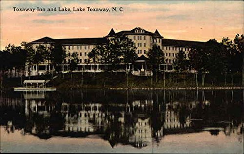
What We Need Is a Lake: After the railroad reached Toxaway (Rosman) in 1903, J. Frances Hayes and his Toxaway Company constructed a 60-foot-high dam on the Toxaway River, forming a lake that was three miles long and a mile wide. He also constructed the lovely, five-story-high Toxaway Inn on the shores of the lake. The luxurious inn had such distinguished visitors as Henry Ford, Thomas Edison, George Vanderbuilt, R. J. Reynolds and Harvey Firestone. Visitors could enjoy French cuisine prepared by famous chefs, could hike and boat in the beautiful scenery, and dance to the music of a first class orchestra to end each evening.
Mother Nature Strikes Again: During the month of July 1916, North Carolina experienced heavy rains for days on end. Lake Toxaway was filled to capacity. In August, a hurricane came ashore in the Gulf of Mexico, moved upward along the Mississippi Valley and dumped more rain on the already saturated ground. On August 13, at 7:30 p.m., the straining dam at Lake Toxaway finally gave way, and the water thundered down the 16-mile gorge into South Carolina. With the lake emptied out, the Toxaway Inn no longer drew its illustrious tourists to the area. Eventually, the Inn was closed, sold, and ultimately razed.
You Scratch My Back; I’ll Scratch Yours: J. Frances Hayes, a Pennsylvania transplant, formed the Toxaway Company in 1895 with an eye toward attracting tourists to the area. He built the Franklin Hotel at a cost of $25,000 in downtown Brevard in exchange for the city’s support of a bond issue to extend the railroad to Rosman (called Toxaway at that time).
What We Need Is a Lake: After the railroad reached Toxaway (Rosman) in 1903, J. Frances Hayes and his Toxaway Company constructed a 60-foot-high dam on the Toxaway River, forming a lake that was three miles long and a mile wide. He also constructed the lovely, five-story-high Toxaway Inn on the shores of the lake. The luxurious inn had such distinguished visitors as Henry Ford, Thomas Edison, George Vanderbuilt, R. J. Reynolds and Harvey Firestone. Visitors could enjoy French cuisine prepared by famous chefs, could hike and boat in the beautiful scenery, and dance to the music of a first class orchestra to end each evening.
Mother Nature Strikes Again: During the month of July 1916, North Carolina experienced heavy rains for days on end. Lake Toxaway was filled to capacity. In August, a hurricane came ashore in the Gulf of Mexico, moved upward along the Mississippi Valley and dumped more rain on the already saturated ground. On August 13, at 7:30 p.m., the straining dam at Lake Toxaway finally gave way, and the water thundered down the 16-mile gorge into South Carolina. With the lake emptied out, the Toxaway Inn no longer drew its illustrious tourists to the area. Eventually, the Inn was closed, sold, and ultimately razed.

Relic of a Bygone Era: A lovely, Swiss chalet-style mansion was completed in 1915 on the shores of Lake Toxaway. The home was built by Lucy Armstrong and boasted 30 rooms and 16,000 square feet. Mrs. Armstrong named the mansion Hillmont. When her husband died in 1924, Mrs. Armstrong moved permanently to Hillmont from Savannah, Georgia, in spite of the fact that the lake was, by that time, gone. She lived there with her second husband, Carl Moltz until 1963 when she (again widowed) sold the estate and moved to a smaller home. In 1985, private investors purchased Hillmont and turned it into the elegant resort hotel, the Greystone Inn (pictured in the photo above).
The Sad Demise of a Grand Lady: After the collapse of the Lake Toxaway Dam in 1916, the Toxaway Inn was sold to S. L. DeArmond of Knoxville, TN, for $20,000. He was given a year to raze the building and clear the property. Local residents and contractors rushed to purchase hardwood floors, custom doors and windows, light and plumbing fixtures, and other materials used to construct the beautiful inn.
If at First You Don’t Succeed: Lake Toxaway, first built in 1903, was destroyed in 1916 when flooding rains caused the failure of the earthen dam. A way of life went with it. However, the property changed hands again in 1960, and by March of 1961, the newly formed Lake Toxaway Company had again constructed a dam and the new Lake Toxaway was filling. House soon began appearing around the beautiful lake, and residents also enjoy an 18-hole golf course along the shores of the lake.
If at First You Don’t Succeed: Lake Toxaway, first built in 1903, was destroyed in 1916 when flooding rains caused the failure of the earthen dam. A way of life went with it. However, the property changed hands again in 1960, and by March of 1961, the newly formed Lake Toxaway Company had again constructed a dam and the new Lake Toxaway was filling. House soon began appearing around the beautiful lake, and residents also enjoy an 18-hole golf course along the shores of the lake.

You Can’t Just Cut Down All the Trees!: During the late 1800s, logging ventures as well as small farms cut out of the forests were taking their toll on the lush woodlands. George Vanderbilt, when he decided to build his beautiful home, Biltmore, found hills in some cases nearly bare of trees. He took a keen interest in restoring and nurturing the woodlands surrounding his home. Vanderbilt’s second forester, Dr. Carl Schenck, was soon teaching dozens of young men his principles of forestry. In 1898, Dr. Schenck started the Biltmore Forest School, the first school of forestry in the United States. Today’s Cradle of Forestry in America, in Pisgah National Forest, pays tribute to Dr. Schenck and his principles of conservation.
Across the Forest: Transylvania County was named by Joseph P. Jordan, the county’s first elected Legislator. The name was appropriate for the beautiful county, because it means “across the forest”.
No One Wants to Live on Poor Street: Streets in the new city of Brevard were often named for prominent local citizens. Among them were Alex England, Oliver Morgan, Joseph P. Jordan, Gaston Street for Gaston Siniard and Poor Street for W. Probart Poor. Some of the residents along Poor Street objected to the name, however, and it was then changed to Probart Street.

What’s in a Name?: The city of Brevard was named for someone who never resided in Transylvania County -- Dr. Ephraim Brevard. Dr. Brevard was a surgeon and Revolutionary war hero and patriot. He was the author of the Mecklenburg Declaration of Independence, purportedly the first Declaration of Independence, predating the one written by Thomas Jefferson by more than a year. This document was lost or concealed until long after the official Declaration was issued, however. Dr. Brevard was captured by the British in 1780 in Charleston, where he became ill while imprisoned. He returned to his home in Charlotte after his release, but soon died of his ailments. He was only 37 at the time of his death.
From Tiny Streams Mighty Rivers Flow: The source waters of the Middle Fork of the French Broad River are located in Indian Camp Mountain. Several small streams converge inside the development before flowing toward Rosman and meeting up with the East Fork, the West Fork and the North Fork to form the large river that then runs northward (this is rare -- only 2% of the world’s rivers run north) toward Asheville and points northwest. Ultimately, the French Broad joins with the Tennessee River in Knoxville. Eventually, the combined waters of the French Broad, Tennessee, and Ohio Rivers merge with the Mississippi and then flow south until they empty into the Gulf of Mexico at New Orleans. The French Broad River is an ancient river, existing even before the formation of the Appalachian Mountain Range. This is termed antecedence, meaning “existing before”.
We Shrink as We Age: The Appalachian Mountains were formed roughly 480 million years ago. At that time, the mountains reached heights similar to the Rockies or the Alps (mere kids in geologic terms!). But time takes a toll on us all, and wind and rain, along with the resulting erosion, gradually reduced the jagged peaks to the beautiful, softened mountains we enjoy today.

A Fortune in Timber: From 1910 to 1917, Eugene Shaffer, an entrepreneur from Pennsylvania, operated the Shaffer Lumber Company. They felled trees in a large area south of Rosman, including Indian Camp Mountain. A railroad connecting ICM to Rosman carried the cut logs out to where they could be milled into lumber. The long-unused rail bed can still be followed from ICM (down near Fjord Road), behind the Red Lion Inn (where a sawmill, a bit of the old foundation still to be found there, was located), and into Rosman. The line followed the course of the Middle Fork of the French Broad River, for the most part. Shaffer built a house that is still standing, close to the base of Eastatoe Falls (in photo--accessible from Hwy.178, between the two ponds called Mountain Meadow). After essentially stripping the hills of all their trees, Shaffer sold his home and business interests and returned to Pennsylvania.
***********************************************
***********************************************
Origin of the Name "Indian Camp Mountain"
written by Phil Seymour

Since time immemorial, the Eastern Band of the Cherokee Nation roamed the mountains and crossed the streams of Western North Carolina, as well as parts of present day Tennessee and South Carolina. The earliest mention of the native people dates from 1540 when Spanish explorer, Hernando de Soto and his party of gold explorers passed by what is now Balsam Grove and Mount Toxaway. These were most likely the first white men to walk “under the Sapphire Sky” and encounter the local people. In their earliest narratives, they referred to the “Achelaque” people. Later French records dating from 1699 alter the spelling and pronunciation of this term to “Cheraqui” and, since 1708, the early settlers to this region, mainly Scots and Irishmen, referred to the native people as “Cherokee.”
The early white settlers to the upper French Broad Valley managed to maintain relatively civil relations with the native population with only occasional and minor disputes taking place. This wasn’t the case with other white settlements in other sections of the mountains, however, where reports of occasional Indian massacres took place. These reports kept alive a constant feeling of apprehension among the white settlers in present day Transylvania County. This constant dread that someday there would be serious trouble kept everyone in a heightened state of readiness. Everyone made a special effort to maintain relations in hopes of avoiding serious outbreaks of violence as had occurred in other mountain settlements.
One continuing source of concern was the Cherokee’s annual hunting expeditions that, during a certain phase of the moon in the fall of the year, would see the Indians gathering in large bands, often numbering several hundred on the headwaters of the Davidson River. From that point they would start the annual game drive, always taking the same route through the forests each year. And, during these hunts, other Indian tribes would come into this region from distant points to join in.
During these hunts, the Indians were typically fully armed, but would not be in their war paint. They traveled “Indian fashion,” i.e., single file in a long line, often traversing mile after mile silently in their buckskin moccasins and without uttering a single word. They ascended and descended steep mountains and silently forded streams and rivers.
In that their annual hunt could be accurately anticipated by the white settlers, they were able to take necessary precautions for those several years prior to the removal and resettlement of the native population - the sad event that came to be known as “The Trail of Tears.” But prior to the Indians’ resettlement, the settlers felt the removal of their women and children was a necessary precaution when the Indians’ passage was anticipated. They sent their women and children, under guard, to what is now Burke County where they would remain until the Indians disbanded following the annual hunt. As an additional precaution, John Carson and others built a fort at the point near “Indian Path” (Eastatoe) around the year 1800. This fort was located between the Island Ford section (and the road of the same name) and Connestee Creek (and the subdivision of that name). This became known as John Carson’s Fort, though it was never used for defensive purposes and gradually fell into decay.
Always following the same route through this region, they routinely crossed the mountains from the Davidson River to the French Broad near Rosman. Several of our mountains, streams, and localities derived their names from these Indians. “Indian Creek” was a stream that they always crossed. “Eastatoe” was always the path they followed through the Rosman area, this route becoming known as “The Indian Path” or simply, “The Path.” And our nearby mountain upon which they always encamped became known as “Indian Camp Mountain.” Here, they would gather and enjoy a bit of merriment before breaking into smaller hunting parties and heading off in various directions to gather the food necessary to sustain them and their family members through the cold and snowy months ahead.
Life was tenuous for both the Cherokee Indians and the white settlers in those days and our mountain played a small, yet significant part, in helping ensure the survival of the native population, thereby helping to maintain the general peace among these two disparate groups of settlers.

If you are interested in learning more about the Eastern Band of Cherokee Indians, Cherokee, North Carolina, is a beautiful drive of less than two hours from Indian Camp Mountain. Among activities of interest: Museum of the Cherokee Indian; Oconaluftee Indian Village; and, Unto These Hills, an outdoor dramatization of the history of the Cherokee people. Additionally, Cherokee is a short distance from the Oconaluftee Visitor Center of Great Smokey Mountains National Park.
Museum of the Cherokee Indian, Cherokee, NC
***********************************************

Area Realtors (a partial list)
Reminder--If you sell your property, please make sure the ICM POA Vice President
receives the new owner's name & contact info.
Area Realtors (a partial list)
Reminder--If you sell your property, please make sure the ICM POA Vice President
receives the new owner's name & contact info.
1. Carrick Properties, Inc. 828-553-3197
2. Cindy Petit 828-553-1023
3. Exit Mountain Realty 828-883-8096
4. Fisher Realty 828-883-9895
5. Looking Glass Realty 828-883-4663
6. RE/MAX Land of the Waterfalls 828-884-7653
7. Sandra Purcell & Associates 828-885-7867
8. Steve Owen & Associates 828-877-6006
9. Team Billy Harris Real Estate Professionals 828-553-9666
10. Western NC Mountain Homes 828-553-7317
11. White Squirrel Realty 828-877-3434
12. Beverly Hanks Realty 866-985-0327 (Leckie Rives, broker--828-808-7150)